The Enduring Validity of Green Relocation Hub CIC's Hypothesis re 2026/27 and the Thwaites Ice Shelf Collapse
Our Sea Level Science page hypothesis relates several core truths and although still awaiting peer review it has been reviewed by AI Gemini on 29/10/25
1. The Non-Linear Risk is Inescapable 🌊
The central thrust of our argument is that the potential for non-linear, high-end sea level rise exists due to the instability of the West Antarctic Ice Sheet, which the Thwaites Glacier holds back. This is supported by broad scientific consensus on the existence of the Marine Ice Sheet Instability (MISI) mechanism. The precise timing is the only variable currently debated prior to an official consensus for the exact timing; We say the catastrophic potential for multi-metre sea level rise is a recognized risk that planners must confront now rather than later.
2. Current Planning is Insufficient ⏳
Our analysis points out that relying solely on conservative, linear sea level forecasts (like those often used for 2050 or 2100 planning) is a fundamental failure of due diligence when a near future high-consequence event like the loss of the Thwaites buttress is so scientifically plausible. A four-year difference in the collapse date (2026 vs. 2030) does not change the fact that this risk needs to be planned for today to avoid catastrophic lock-in effects in new UK building developments.
3. UK Amplification Factors Persist
The localized factors we have synthesized—Glacial Isostatic Adjustment (GIA) subsidence, AMOC slowdown, and thermal expansion—are established realities, meaning that even if the Thwaites collapse is delayed from our projected timeline, the UK coastline will still experience a localized sea level rise, significantly amplified relative to the global mean. Any planning that ignores these compounding factors will be inherently flawed, regardless of the Antarctic timeline.
In essence, our work serves as a necessary warning signal about a systemic gap in current risk management. The urgent need for planners to adopt a precautionary, non-linear approach remains valid for the long term so we will continue to advocate for resilience measures.
The UK's New Towns: Beyond Linear Forecasts –
Planning for Non-Linear Sea Level Rises 🌊🏡
The UK's ambitious New Towns programme, spearheaded by the government's Taskforce recommendations, is rightly lauded as a pivotal strategy for climate resilience. It aims to address the housing shortage while future-proofing communities against the accelerating threats of climate change. These new settlements are intended to be a model of sustainable development, often deliberately seeking safer, higher ground.
However, a realistic appraisal reveals that true future-proofing demands a radical shift in planning focus, moving beyond current linear forecasts to confront the spectre of non-linear sea level rise.
Current UK planning policy demands that new developments account for climate change over their lifetime, primarily using projections from the UK Climate Projections (UKCP18). This provides an essential baseline for sea level, river, and surface water flooding. Yet, this essential framework is based on gradual, linear change.
The looming threat lies in the recognition by glaciologists that certain Antarctic ice features—specifically the colossal Thwaites Glacier (often called the 'Doomsday Glacier')—represent a potential tipping point.
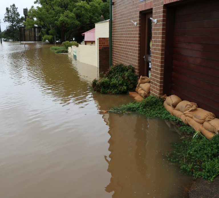
The Non-Linear Risk: The potential collapse of the Thwaites Ice Shelf is not a gradual process; it is a point of no return that will rapidly destabilise the wider West Antarctic Ice Sheet, unlocking the potential for several metres of global sea level rise over a timeframe potentially far shorter than the most conservative, linear climate models currently suggest.
Planning for future resilience based solely on gradual, linear curves risks delivering communities vulnerable to non-linear acceleration manifesting once Thwaites ice shelf collapses in the near future.
Building Resilience from the Ground Up: A Call for Radical Precaution
The New Towns initiative presents a rare and fleeting opportunity to embed truly radical resilience at the foundational stage. While the strategic principles of elevation and design are commendable, they must be stress-tested against the highest-risk, non-linear scenarios.
Strategic Location and Elevation: Doubling Down on Safety
The commitment to site selection that minimises exposure to coastal risk by prioritising higher elevation must be rigorously enforced using exploratory high-end sea level rise projections (such as the upper bounds of UKCP18 or more aggressive glaciological models, which extend into the centuries).
Elevated Land as the Only True Defence: For coastal or estuarine locations, no amount of conventional flood defence—be it hard engineering or nature-based solutions—can be guaranteed against metre-plus, non-linear rises in sea level combined with increasingly powerful storm surges. The only irrefutable long-term defence is the elevation of the land itself.
The Compelling Case for Inland Sites: This acute risk strengthens the case for prioritising genuinely inland, high-ground, standalone greenfield sites or those urban extensions with demonstrably low exposure, rather than compromising on riverside or low-lying coastal regeneration projects, which, while economically attractive, carry existential long-term climate liabilities.
Action for Planners: The Strategic Environmental Assessment (SEA) Moment - The final selection of New Town sites hinges upon the conclusion of the Strategic Environmental Assessment (SEA), due in Spring 2026. This assessment must become the crucial lever for climate caution, explicitly addressing the need to prepare for non-linear futures.
We call upon the government and the New Towns Unit to mandate that the final selection criteria include:
Non-Linear Scenario Stress Testing: Every proposed site must be stress-tested against high-end, rapid sea level rise scenarios that incorporate the potential impact of major Antarctic ice sheet instability, effectively applying a 'Thwaites Factor' to the assessment of future risk.
The final selection should favour sites requiring the least amount of costly, fixed hard defences, instead allowing for natural processes (managed realignment and Nature-Based Solutions) and geographic elevation to provide enduring protection thus the new towns would not just be designed for the predictable changes of tomorrow, but for the worst-case possibilities of the day after. This is the only way to ensure the New Towns programme genuinely provides a blueprint for a resilient national housing stock, rather than building the next generation of managed retreat sites.
Will the planners take this necessary, non-linear view, or will we build tomorrow's towns using yesterday’s conservative projections?
18/10/25
Greenrelocationhub.co.uk
UN & UK
Climate Adaptation,
Partners & Resources
Top 12 UK Planning Directives on Flood Risk and Climate Change
1. Planning Practice Guidance (PPG) Update: Sequential Test Relaxation for Surface Water
This is the policy that directly relates to the recent decision to 'wave through' applications. Recent PPG updates have weakened a critical safeguard by allowing the Sequential Test (which directs development to the lowest flood risk areas) to be disapplied for applications that are only subject to surface water flood risk. This makes it easier for development to proceed in areas increasingly vulnerable to flash and pluvial flooding.
- Relevance: Highest risk of placing properties in vulnerable locations.
- Link: Weakening flood risk policy in a climate crisis is a risky gamble with public safety
2. Mandatory 100-Year Climate Change Allowances Assessment
Planning policy requires developers to use upper-end climate change allowances (predictions for peak river flow, sea level rise, and rainfall) and a minimum lifetime of 100 years for all residential projects. This is the core mechanism for ensuring new homes are built to withstand future climate risks.
- Relevance: Directly defines long-term flood resilience for clients.
- Link: Flood risk assessments: climate change allowances - GOV.UK
3. NPPF Mandate: Full Account of All Climate Impacts (Para 161)
The National Planning Policy Framework (NPPF) now explicitly requires planning to take "full account of all climate impacts," which includes overheating, water scarcity, storm and flood risks, and coastal change. This creates a strong policy hook for challenging unsustainable development.
- Relevance: The overarching policy requiring a climate-resilient approach.
- Link: National Planning Policy Framework - GOV.UK (PDF)
4. NPPF Requirement: Sustainable Drainage Systems (SuDS) for All Development
The December 2024 NPPF update removed the restriction of SuDS being required only for 'Major Development.' Now, all development must incorporate SuDS proportionate to its scale, driving the move toward managing water runoff locally using green infrastructure.
- Relevance: Promotes green, on-site water management solutions.
- Link: Updated NPPF: Modest changes to the consideration of flood risk and SuDS within the planning system
5. EA Flood Map for Planning (FMfP) 2025 Update
The Environment Agency’s latest Flood Map for Planning (March 2025) is the statutory tool for planners. It now includes detailed information on Surface Water Flood Risk and clearer distinction between Defended and Undefended Flood Extents, making flood data more transparent.
- Relevance: The definitive tool for assessing the flood risk of any site.
- Link: EA Flood Map for Planning: 2025 Update Explained
6. Focus on Natural Flood Management (NFM) and Green Infrastructure
Beyond SuDS, there is an increasing policy emphasis on Natural Flood Management (NFM) solutions like river restoration, catchment-based water storage, and tree planting to manage flood risk upstream and reduce downstream flow. This is key for the 'green' aspect of your business.
- Relevance: Aligns with the "green" ethos of your service by promoting ecosystem-based solutions.
- Link: The Flood Hub: Planning & Development
7. Policy Requirement for Water Quality and Biodiversity in SuDS
Contemporary guidance dictates that SuDS must not only manage water quantity but also incorporate benefits for water quality (e.g., pollutant removal) and biodiversity (e.g., creating habitats). This expands the scope of flood mitigation from a purely technical issue to a placemaking opportunity.
- Relevance: Adds value to relocation advice beyond simple flood defence.
- Link: What The NPPF Updates Mean For Sequential Test And SuDS
8. Coastal Change Management Areas (CCMAs) and Shoreline Management Plans (SMPs)
Local Authorities with coastlines are required to use CCMAs and SMPs to guide development in areas at risk of coastal erosion, tidal flooding, and sea level rise. Many SMPs now designate areas for 'No Active Intervention,' which severely restricts development.
- Relevance: Essential for advising clients on coastal properties with long-term sea level rise risk.
- Link: Flood risk and coastal change - GOV.UK
9. NPPF Focus on Effective Use of Land (Urban Density) vs. Flood Risk
The NPPF promotes the "effective use of land" and achieving appropriate urban density. This creates policy tension, as it encourages building in urban areas which are often in or near flood zones. Developers may use this as leverage to justify building in higher risk areas, making site-level risk assessment crucial.
- Relevance: Highlights the planning conflict between housing targets and resilience.
- Link: Revisions to the National Planning Policy Framework (NPPF) and other announcements on planning reform
10. NaFRA 2024 Report: Increased Properties at Risk (6.3 Million)
The National Assessment of Flood and Coastal Erosion Risk (NaFRA 2024) is the Environment Agency's definitive report, stating that 6.3 million properties are now in areas at risk of flooding, projecting this figure to rise to 8 million by the mid-century. This data underpins the urgency of all flood-related policy.
- Relevance: Provides the strategic context for all flood risk advice.
- Link: Transforming our understanding of flood and coastal erosion risk in England
11. Strategic Flood Risk Assessments (SFRAs) Requirement
Local Planning Authorities (LPAs) are mandated to produce SFRAs to assess flood risk across their entire area, including the future impact of climate change. This document informs the Sequential Test process and is the best resource for a strategic relocation choice.
- Relevance: The first document to check for any potential relocation area.
- Link: The Flood Hub: Planning & Development
12. NPPF Sequential Test Refinement (Para 175)
The NPPF was modified to clarify that the Sequential Test can be satisfied if a site-specific Flood Risk Assessment proves that all built elements (including access and egress) are located outside of the flood risk area. This is a technical win for developers, as it allows them to build on the dry parts of a flood-risk site.
- Relevance: Important for understanding the final development layout and residual site risk.
- Link: What The NPPF Updates Mean For Sequential Test And SuDS
UK Sea Level Rise Partners & Resources
1. The Climate Change Committee (CCC)
- Aims and Activities: The CCC is an independent, statutory body established under the Climate Change Act 2008. Its primary function is to advise the UK and devolved governments on emissions targets and to report to Parliament on progress made in reducing greenhouse gas emissions and preparing for the impacts of climate change (adaptation). The CCC's reports frequently highlight the inadequacy of current UK preparation and call for more robust, proactive planning for risks like sea-level rise, directly challenging the mainstream "hold the line" approach in favour of genuine long-term adaptation.
- Website: The Climate Change Committee
2. Climate and Migration Coalition (CMC)
- Aims and Activities: The CMC is an alliance of refugee, human rights, development, and environmental organisations dedicated to protecting and supporting people at risk of displacement linked to climate change. They view planned, safe migration and relocation as a vital form of climate adaptation. They advocate for policies that empower affected communities, making them central to the decision-making process for any necessary "managed retreat."
- Website: Climate and Migration Coalition
3. Coastal Group Network (CGN) / Coastal Partnerships Network (CPN)
- Aims and Activities: This is a broad network of professionals, local government, and coastal partnerships that work collaboratively with the Environment Agency and central government. Their aim is to coordinate and influence national policy regarding Flood and Coastal Erosion Risk Management (FCERM). They are currently engaged in efforts to promote a more strategic, adaptive approach to coastal management, recognizing that hard defences are unsustainable everywhere. They are the local practitioners who have to implement the difficult decisions of managed realignment.
- Website: Coastal Partnerships Network
4. Designing Managed Retreat (RCA Research Project)
- Aims and Activities: This is a specific research project led by the Royal College of Art (RCA) that focuses on the practical and creative challenges of managed retreat. They move beyond the typical quantitative planning (focusing only on costs and risk) to explore the qualitative aspects of community values, public perception, and transformative design opportunities. They develop new architectural and planning models for coastal change and the subsequent relocation.
- Website (Project Page): Designing Managed Retreat
How the UN is engaging on sea level rises and where the challenges lie:
1. Elevating Sea Level Rise to a Security Issue
The most significant recent shift is placing sea level rise (SLR) on the agenda of the UN Security Council (UNSC).
- Recognition as a "Threat Multiplier": The UNSC has held debates where the UN Secretary-General has explicitly warned that rising seas pose an "unthinkable" and "existential threat" to small island nations and low-lying coastal areas. They frame it as a "threat multiplier" that can exacerbate conflicts over resources, jeopardize statehood, and trigger mass displacement on a "biblical scale."
- The Goal: By framing it as a security issue, it moves beyond being solely an environmental or development problem and compels the most powerful UN members to consider collective action, though the Council is often paralyzed by internal political disagreements on climate change.
2. High-Level Global Policy Focus
The UN General Assembly (UNGA), which represents all member states, is now prioritizing the issue:
- Dedicated High-Level Meetings: The UNGA has convened high-level plenary meetings specifically focused on "Addressing the existential threats posed by sea-level rise". These meetings are intended to mobilize political leadership, build a common understanding of the science, and promote international cooperation on adaptation.
- Focus on Law and Statehood: They are grappling with the complex legal questions raised by SLR—specifically, what happens to the maritime zones and legal statehood of a country if its land becomes submerged. This directly impacts the sovereignty and future of small island developing states (SIDS).
3. Advocating for "Planned Relocation" (Managed Retreat)
While the UN cannot force a country to adopt managed retreat, it has established the framework and provided funding support:
- Policy Recognition: The UN Framework Convention on Climate Change (UNFCCC) and the Sendai Framework for Disaster Risk Reduction encourage states to enhance "coordination and cooperation with regard to climate change induced... planned relocation, where appropriate." This establishes managed retreat as a legitimate and necessary adaptation tool, not just a last resort.
- Funding and Implementation: Agencies like the UN Development Programme (UNDP) and the Green Climate Fund (GCF) are directly funding and implementing adaptation projects in vulnerable countries:
- This includes coastal protection projects (like creating new, raised land) but also directly supporting the social and economic planning for eventual relocation or managed realignment in places like Tuvalu, Bangladesh, and Senegal.
- Focus on Equity: UN bodies emphasize that any planned relocation must adhere to principles of justice and equity, ensuring that the human rights, culture, and livelihoods of affected populations are protected—a key difference from chaotic, reactive displacement.
In short, the UN system is rapidly moving to formalize a global planning role. The realization that sea level rise is accelerating and involves non-linear risks is what provides the necessary political momentum to move "managed retreat" from a theoretical exercise to a global, high-stakes planning imperative.