Antarctica's 'Doomsday' Ice Shelf: Why Late 2026 is Critical to Thwaites and the World
2026 King Tide Trigger Hypothesis
🚨 The Convergence of Cryosphere Collapse and Astronomical Force: A Strategic Assessment of the Thwaites Glacier Inflection Point and UK Coastal Preparedness
Executive Summary: The Geohazard Inflection Point
The structural integrity of the Thwaites Eastern Ice Shelf (TEIS) is critically compromised. The convergence of its advanced physical degradation with peak, predictable astronomical tidal forces establishes a critical, non-linear inflection point for global sea-level rise (SLR) policy in the definitive timeframe of Late 2026 / Early 2027. This window is when the primary buttress of the Thwaites Glacier (TG) is expected to fail, fundamentally and irreversibly accelerating global sea-level trajectory.
The TEIS is extensively pre-conditioned for failure, with satellite data confirming rapid fragmentation, including rifts propagating inward at rates reaching 2 kilometers per year. Following the buttress loss, the resultant acceleration of grounded ice discharge will interact with UK-specific geophysical factors, guaranteeing localized sea-level rise significantly exceeding the global average. This disproportionate impact stems from Gravitational Fingerprint amplification (forecast to be more than 20% above the eustatic average) and Glacial Isostatic Adjustment (GIA) subsidence, where Southern UK is sinking at rates up to 5 cm per century. The predicted increase in mean sea level (MSL) will interact disastrously with the bathymetry of highly resonant systems, such as the Severn Estuary and Bristol Channel, hydrodynamically amplifying high-water flood levels (tidal funnelling) and threatening critical coastal infrastructure. The Late 2025 / Early 2026 window is a necessary hard deadline for strategic reassessment, demanding an immediate transition from linear projections to non-linear resilience planning to include urgent stockpiling of modular homes for the UK..
Section I: Thwaites Glacier and the Marine Ice Sheet Instability (MISI) Risk
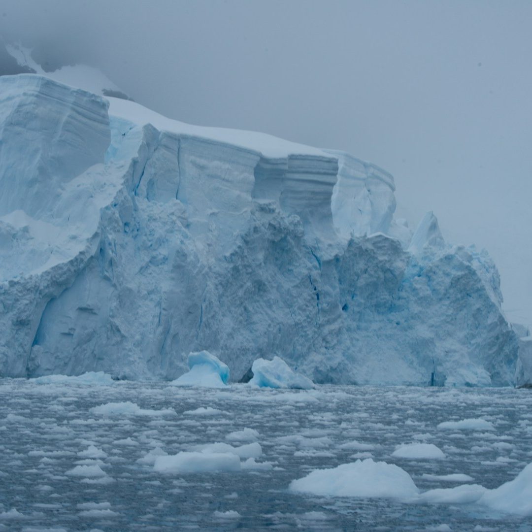
The Thwaites Glacier, the "Doomsday Glacier," is the most critical factor in future global SLR. It currently contributes the largest single-glacier mass to sea-level rise and acts as a critical anchor for the broader West Antarctic Ice Sheet (WAIS). Its total collapse potential is 65 centimeters (2.13 feet), with a cascading collapse of neighboring glaciers potentially exceeding 3 meters (8 feet). Note this projection is a global average figure and the UK will be disproportionately affected.
Thwaites' acute vulnerability lies in its classification as a marine-based glacier resting on a retrograde slope (deepening inland), which is the fundamental condition for the irreversible Marine Ice Sheet Instability (MISI) feedback loop. The glacier's grounding line has already retreated 14 kilometers since the late 1990s, confirming the unstable process is active.
The short-term rate of this instability is controlled by the Thwaites Eastern Ice Shelf (TEIS), which buttresses one-third of the main ice stream and slows its flow to 600 meters per year, compared to the main body's 2000 meters per year. Removal of the TEIS buttress will allow this constrained ice to accelerate, representing an immediate 25% increase in total annual ice discharge (from 180 km to 240 km per yea). This immediate jump establishes the inflection point, fundamentally changing the policy requirement from managing long-term volume risk to mitigating imminent acceleration risk.
Section II: Pre-Conditioned Fragility: Structural Degradation of the TEIS
The TEIS is structurally compromised and requires only a final, cyclical stress for failure.
- Advanced Mechanical Failure: The TEIS shows extensive brittle failure, including the propagation of rifts into the central shelf at up to 2 kilometers per year, seeded by earlier acceleration between 2002 and 2006. NB A 2012 crack in the neighbouring Pine Island Glacier was measured to propagate at 80Kmph.
- Loss of Basal Contact: The shelf is actively losing its grip on its crucial submarine pinning point. Ground-based GPS measurements show that ice velocity has nearly doubled since 2019, a direct, measurable consequence of this progressive decoupling.
- Thermal Weakening: Warm, salty Circumpolar Deep Water (CDW) causes rapid, localized melting in cracks, crevasses, and along basal topography, confirmed by the International Thwaites Glacier Collaboration (ITGC) MELT project. The final collapse is predicted to occur when the rapidly propagating surface rifts intersect a critical weak basal zone.
This fragility is the result of accumulated damage, setting the stage for a critical environmental force to provide the final breaking strain.
Section III: Astronomical Forcing and the Precision Timeline: The Late 2026 Convergence
The predictive focus on the Late 2026 / Early 2027 window incorporates the role of maximum, predictable astronomical forces acting upon the structurally pre-conditioned ice shelf.
Ocean tides influence stability by inducing cyclical bending (flexure), which stresses the ice over the pinning point and across existing fracture lines, directly influencing the timing of major calving events (e.g., the Brunt Ice Shelf calving coinciding with a peak spring tide). Tides also critically transfer heat, with global ocean modeling showing that tidal processes increase total Antarctic basal mass loss by 4%p.a..
The "King Tides" (perigean spring tides) maximize the combined gravitational pull. In the context of the highly damaged TEIS, these forces apply the maximum breaking strain through two mechanisms:
- Amplified Flexure: Maximum tidal range stresses the damaged ice past its ultimate limit.
- Enhanced Pumping: The maximum tidal range dramatically increases the volume and pressure of warm CDW being forced into the sub-shelf cavity and beneath the exposed grounding line, maximizing the thermal assault at the most sensitive location for MISI.
The precision of the failure window is further refined by the Earth reaching perihelion (closest approach to the Sun) around January 3rd, which aligns with the Southern Hemisphere's summer solstice. This pulse of solar energy elevates the overall thermal state of the Southern Ocean. The highest risk occurs due to the synchronization of forces in December 2026: the final, extra high tide occurs when the structure is simultaneously subjected to the maximum annual thermal forcing (a 6.8% insolation boost). This synergistic combination of maximum gravitational stress and peak thermal input is highly probable to trigger the catastrophic detachment event. (The full critical convergence window is detailed in Attachment B.)
NB Recent observations on the Brunt Ice Shelf, particularly the calving of Iceberg A-81 in January 2023, have established that while long-term glaciological stresses control the formation of major cracks (rifts), the timing of a calving event is often controlled by external environmental forces. Specifically, analysis demonstrated that the final break-off consistently occurred at the peak of a spring tide (around new and full moons), when the highest tidal range exerts maximum vertical flexing and stress on the floating ice shelf. This finding is significant because it introduces a predictable, short-term factor (ocean tides) into forecasting when major ice loss events will occur, which helps refine models for the stability and ice flow dynamics of other crucial Antarctic ice shelves like the one buttressing Thwaites Glacier.
Section IV: The Irreversible Trajectory: Non-Linear Acceleration of Global Sea-Level Rise
The loss of the TEIS buttress in Late 2026 / Early 2027 initiates rapid-onset acceleration of the grounded ice, instantly switching the global sea level trajectory from a decades-long linear path to a much steeper, high-end curve.
The grounded ice discharge rate is projected to increase by 25% instantaneously. This rapid increase in mass loss is the definitive signal that the MISI feedback loop is fully engaged. This shift mandates planning to account for an elevated rate of rise that drastically shortens the effective lifespan of existing coastal defence schemes.
The loss of TEIS is the critical first irreversible step toward cascading collapse that risks drawing in neighboring glaciers, most notably the Pine Island Glacier (PIG). Should this occur, the total WAIS contribution could reach 3.3 meters of global SLR. (The stages of Thwaites contribution are outlined in Attachment C.)
Section V: Local Amplification: Strategic Implications for Coastal UK
The accelerated ice discharge will produce disproportionately high relative SLR effects for the UK due to two unique, amplifying geophysical factors:
- Gravitational Fingerprint Effect: As the immense mass of the WAIS diminishes, its gravitational pull wanes, and the released water mass is redistributed. Geophysical models indicate the North Atlantic, including the UK, will experience a peak sea-level rise greater than 20 to 25 per cent above the eustatic value.
- Glacial Isostatic Adjustment (GIA) Subsidence: The southern half of Great Britain is experiencing post-glacial crustal depression (sinking) at rates up to 5 centimeters per century.
The southern UK therefore faces a severe "double geodynamic penalty," as it is both geologically sinking and geographically positioned to receive a disproportionate influx of accelerated meltwater. This convergence mandates an immediate and fundamental update to strategic modelling. (The UK amplification factors are summarized in Attachment D.)
Section VI: Case Study: Hydrodynamic Risk in the Severn Estuary and Bristol Channel
The Severn Estuary possesses the world's second-largest tidal range (up to 15 meters), resulting from a powerful funnelling effect and quarter-wavelength resonance. It is classified as a converging estuary, a system highly sensitive to deleterious effects from sea-level rise.
An increase in MSL will not simply add water depth; it will fundamentally alter the resonant properties. Hydrodynamic modeling confirms that SLR often amplifies the tidal range in converging estuaries. As the water column deepens, the efficiency of wave compression and resonance increases, maximizing the channel’s natural capacity to generate high tides. The resultant increase in tidal range (TR) means the absolute maximum water level during high tide will be significantly higher than the baseline MSL increase alone would predict. This funnelling effect directly endangers major communities and critical infrastructure from Cardiff to Gloucester, as historically extreme flood levels will begin to be exceeded regularly by predictable high-spring tides.
Section VII: Conclusions and Time-Critical Policy Recommendations
The scientific consensus supports a high-probability TEIS failure window of Late 2026 / Early 2027, triggered by the convergence of mechanical fragility and maximum astronomical forces. This will initiate an immediate 25% increase in annual ice loss, committing the UK to a highly amplified local sea-level rise challenge due to the Gravitational Fingerprint effect (>20% amplification) and GIA subsidence.
Recommendations for Strategic Defence Planning
- Mandate Non-Linear Modelling and Scenario Planning: All UK planning should immediately transition away from linear historical extrapolation. Future models must explicitly incorporate the post-2026 accelerated ice discharge rate, the Gravitational Fingerprint amplification factor, and regional GIA subsidence rates.
- Accelerate Planning Horizons and Reassess Asset Lifespan: The Late 2025 / Early 2026 window must be treated as the hard deadline for strategic policy formulation. All major coastal capital projects must be stress-tested against the new, steeper SLR curve to reassess the effective lifespan of current defence assets.
Section VI: Case Study: Hydrodynamic Risk in the Severn Estuary and Bristol Channel
The Severn Estuary and Bristol Channel represent a location where the anticipated acceleration in mean sea level (MSL) interacts with highly dynamic hydrographic features, leading to severe localized amplification of flood risk.
6.1. The Physics of Extreme Tides: Funnelling and Quarter-Wavelength Resonance
The Severn Estuary is renowned for possessing the world's second-largest tidal range, peaking at approximately 15 meters, trailing only the Bay of Fundy. This extreme range is a result of a highly specific confluence of oceanographic and bathymetric factors.
The tidal dynamics are driven primarily by two mechanisms: first, the distinct, wedge-shaped geometry of the channel, which creates a powerful funnelling effect at the upper reaches; and second, the quarter-wavelength resonance between the channel length and the incident North Atlantic tidal wave. The channel is classified as a converging estuary—a type of shallower system with strong tidal flows that hydrodynamic models confirm are the most sensitive to deleterious effects from sea-level rise.
6.2. Modelling the Amplification: How Mean Sea Level Rise Exaggerates Tidal Amplitude
An increase in MSL, resulting from the accelerated discharge of the Thwaites Glacier, will not simply result in a linear addition of water depth; it will fundamentally alter the resonant properties and the efficiency of the funnelling mechanism. Hydrodynamic modeling confirms that sea-level rise often amplifies the tidal range in converging estuaries.
As the water column within the fixed funnel geometry deepens, the efficiency with which the incoming tidal wave's energy is compressed, reflected, and resonates increases. This dynamic funnelling effect effectively maximizes the channel’s natural capacity to generate high tides. The resultant increase in tidal range (TR) means that the absolute maximum water level achieved during each high tide will be significantly higher than the baseline MSL increase alone would predict.
The physics governing this phenomenon indicates that tidal amplitude varies inversely with the channel's width and depth at mean water level. If SLR causes the cross-sectional flow area to change in a manner that increases the wave compression, the tidal range will increase. This nonlinear response represents a critical exacerbation factor layered on top of the already accelerated MSL rise committed by the TEIS loss.
6.3. Critical Consequences: Increased Inundation Frequency and Force
The combination of a higher mean water level and the hydraulically exaggerated tidal amplitude means that extreme flood events in the Severn Estuary will be pushed to dramatically higher levels and further inland. This change mandates a shift in defence strategy, as historically extreme flood levels (e.g., the 1-in-100 year event) will begin to be exceeded regularly by predictable high-spring tides, even in the absence of severe storm surges.
The consequences for infrastructure are acute. The elevated MSL and increased tidal amplitude will dramatically raise the force and frequency of saltwater inundation and erosion on coastal defences, mudflats, and low-lying assets. This will severely challenge the viability of existing flood alleviation schemes designed for the region. The intensified funnelling effect directly endangers major coastal communities and critical infrastructure situated along the Severn Estuary and Bristol Channel, spanning regions such as Cardiff, Newport, Bristol, and Gloucester. Consequently, the late 2026 / early 2027 window represents an unparalleled and time-critical point of inflection for regional infrastructure and resilience planning.
Section VII: Conclusions and Time-Critical Policy Recommendations
7.1. Synthesis of the Near-Term Geophysical Risk
The scientific consensus regarding the Thwaites Eastern Ice Shelf points toward advanced, irreversible structural failure driven by the convergence of inward-propagating rifts and upward thermal erosion. The hypothesis that the maximum, predictable gravitational and thermal forcing of the 2026 King Tides and Perihelion will deliver the final cyclical breaking strain is scientifically robust, creating a high-probability failure window of Late 2026 / Early 2027.
The loss of the TEIS buttress will initiate the rapid acceleration of grounded ice discharge, quantified as an immediate 25% increase in annual ice loss. This event is the geophysical trigger that fundamentally commits the global sea level trajectory to a high-end, non-linear curve. For the UK, this accelerated discharge combines with the Gravitational Fingerprint effect (local amplification >20% above eustatic average) and ongoing GIA subsidence (Southern UK sinking up to 5 cm/century) to create a highly amplified and immediate local sea-level rise challenge. In vulnerable estuarine systems like the Severn, the rising MSL will dynamically exaggerate the existing extreme tidal range, pushing extreme flood events significantly higher and further inland.
7.2. Recommendations for Strategic Defence Planning
Based on the established timeline and the scale of the localized amplification factors, the following strategic policy and budgetary actions are recommended:
7.2.1. Mandate Non-Linear Modelling and Scenario Planning
All UK planning, both national and local, must immediately transition away from linear historical extrapolation for sea-level rise projections. Future models must explicitly incorporate the post-2026 accelerated ice discharge rate, the Gravitational Fingerprint amplification factor specific to the North Atlantic, and regional GIA subsidence rates. These models must project the accelerated velocity of rise over the next 30-50 years, which is the operational life cycle of major infrastructure assets.
7.2.2. Accelerate Planning Horizons and Reassess Asset Lifespan
The Late 2026 / Early 2027 window must be treated as the hard deadline for strategic policy formulation. All major coastal capital projects, particularly those with a 50+ year planning horizon, must be stress-tested against the new, steeper SLR curve. This requires a systematic reassessment of the residual value and effective lifespan of current coastal defence assets, harbor infrastructure, and critical facilities designed based on obsolete, linear assumptions.
7.2.3. Prioritize Resilience and Relocation Funding
Given the committed non-linear acceleration, the technical and economic feasibility of resistance through static, height-based barriers must be critically reviewed. Future budgetary planning should prioritize funding for strategies that focus on high-ground resilience, adaptive pathways, planned retreat, and asset relocation schedules over incremental upgrades to existing defence schemes.
7.3. Recommendations for Infrastructure Resilience (Focus on the Severn Estuary)
The unique hydrodynamic vulnerability of the Bristol Channel and Severn Estuary demands immediate, focused action:
7.3.1. Immediate Hydrodynamic Re-Modelling and Mapping
Regional authorities and the Environment Agency must commission urgent, high-resolution hydrodynamic modeling specific to the Severn Estuary. This modeling must incorporate high-end, accelerated MSL scenarios to accurately quantify the dynamically amplified extreme tidal ranges and resulting flood peaks. The outcomes should translate into updated flood risk maps for the entire estuary.
7.3.2. Critical Infrastructure Vulnerability Review
A mandatory, comprehensive stress test must be applied to all critical national infrastructure within the Severn Estuary region—including energy infrastructure, transport links, and essential utilities—focusing on the increased frequency of inundation and the greater erosive force resulting from amplified tidal amplitude and pumping.
7.3.3. Aligning Budgets with Accelerated Risk
Flood defence budgets for the Severn Estuary region must be fundamentally aligned not to current historical risk, but to the steepened, dynamically amplified high-tide regime that the accelerated Thwaites ice loss will trigger immediately post-2026. This requires an urgent budgetary commitment to comprehensive asset relocation planning to mitigate the acute risks posed to communities and the national economy.
M Greenwood, BSc (Hons) Soc Sci & Psychology,
greenrelocationhub.co.uk 30/10/25
Thwaites Ice Shelf - Wikipedia
Collapse of Thwaites Eastern Ice Shelf by intersecting fractures.
On the robustness of predictions of sea level fingerprints - Oxford Academic
The fingerprints of sea level rise
Post-glacial rebound - Wikipedia
Why Severn Estuary - Great Western Power Barrage
Estuarine tidal range dynamics under rising sea levels - PMC - PubMed Central
As 'Doomsday' Glacier Melts, Can an Artificial Barrier Save It? - e360-Yale
Huge cavity in Antarctic glacier signals rapid decay - NASA Sea Level Change Portal
Marine Ice Sheet instability - Antarctic Glaciers
Grounding Lines - AntarcticGlaciers.org
New study provides close-up view of melting beneath Thwaites Glacier | NSF
New close-up view of melting beneath Thwaites Glacier - British Antarctic Survey - News
Rapid fragmentation of Thwaites Eastern Ice Shelf - TC
Suppressed basal melting in the eastern Thwaites Glacier grounding zone - PMC - PubMed Central
Ocean tides trigger ice shelf rift growth and calving - PMC - NIH
The impact of tides on Antarctic ice shelf melting - TC - Copernicus.org
Southern Ocean takes on the heat of climate change - ACEAS
Nonlinear response of the Antarctic Ice Sheet to late Quaternary sea level and climate forcing - TC
Study on tidal resonance in Severn Estuary and Bristol Channel - ResearchGate
Grim outlook for Antarctica's Thwaites Glacier - British Antarctic Survey - News
Hydrodynamic Modelling of Severn Bore and Its Dependence on Ocean Tide and River Discharge - MDPI
Tidal bore revealed by SWOT a case study from the Severn river - DTU Orbit
How Soon Will the Seas Rise? | Quanta Magazine
Antarctic and Southern Ocean influences on Late Pliocene global cooling - PMC

Green Relocation Hub CIC
Astronomical Synergy: Why 2026 King Tide Projections are so High – and What it Means for Thwaites
The year 2026 is poised to deliver exceptionally high "King Tides"—a popular term for Perigean Spring Tides—at a magnitude not seen for nearly two decades. This isn't merely a casual fluctuation; it's the result of a rare and powerful convergence of multiple astronomical cycles, all aligning to amplify the Moon and Sun's gravitational pull on Earth's oceans. Understanding this celestial choreography reveals why 2026 will be a high-water mark, and critically, how these natural forces will conspire with climate change to impact vulnerable ice formations like the Thwaites Eastern Ice Shelf (TEIS).
Triple Alignment: Why 2026's Tides Will Be So High
The phenomenon of a King Tide—the highest predictable non-storm tide of the year—occurs when the Sun, Earth, and Moon align (creating a Spring Tide during a New or Full Moon) and the Moon is simultaneously at its closest point to Earth (Perigee). In 2026, this fundamental alignment is supercharged by three distinct, powerful astronomical cycles all reaching synchronous peaks:-
The 18.6-Year Lunar Nodal Cycle: The Decades-Long Amplifier This is the most significant long-term astronomical influence on tidal heights. The Moon's orbital plane doesn't stay fixed; it slowly "wobbles" or precesses over an 18.6-year period. For roughly half of this cycle, the Moon's orientation amplifies both daily high tides and daily low tides. The period from approximately 2023 to 2026 marks the culmination of this tide-amplifying phase, known as the Major Lunar Standstill. This means that every high tide in 2026 is already receiving a substantial, decades-long gravitational boost, providing an elevated baseline for all other tidal effects.
The 4.4-Year Perigee Cycle: The 'Closeness' Synchronicity While the Moon reaches perigee (its closest point to Earth) every month, the exact timing of this closest approach relative to the Sun-Earth-Moon alignment isn't constant. The Moon's elliptical orbit itself rotates over an 8.85-year cycle. This rotation causes the ideal perigee alignment—where the Moon is both closest to Earth and aligned with the Sun and Earth for a Spring Tide—to peak approximately every 4.4 years (half of the 8.85-year cycle). The year 2026 falls almost perfectly into the peak of this 4.4-year cycle, ensuring that during the crucial Spring Tides, the Moon is simultaneously at its absolute closest to Earth, maximizing its gravitational pull at the most critical times.
The Annual Perihelion Factor: The Seasonal Gravitational & Thermal Bump An often-overlooked but significant factor, particularly for the extreme high tides forecast for late 2026 (especially December), is the Earth's annual proximity to the Sun. Earth's orbit is also elliptical, bringing it closest to the Sun (perihelion) around January 3rd each year.
Gravitational Boost: As Earth approaches perihelion in late 2026, the Sun's gravitational pull on the tides will be at its annual strongest, adding an extra measure of force to the already double-amplified lunar effect.
Thermal Implication: Critically, perihelion coincides with the Southern Hemisphere summer. When Earth is closest to the Sun, the total solar radiation (insolation) received is approximately 6.8% greater than at its farthest point. For Antarctica, this means a significant pulse of additional solar energy delivered precisely when it is most susceptible to melt.
In essence, 2026 represents a rare celestial concurrence where the most powerful gravitational forces of the 18.6-year, 4.4-year, and annual cycles all converge into a simultaneous peak. This creates a high-water event that may not be surpassed for nearly two decades.
The Tidal "Recession": Why the Gap Before 2030
After the exceptional peaks of 2026, the frequency of such extreme high tides will diminish, leading to a noticeable "lull" before they amplify again in the 2030s. This isn't an arbitrary pause but a natural consequence of these complex cycles falling out of their rare synchronicity:
The Fading of the 4.4-Year Cycle: The primary reason for the immediate post-2026 gap is the gradual decay of the favorable 4.4-year alignment. As the Moon's orbit continues to rotate, the precise timing of the monthly Full/New Moon will no longer perfectly coincide with the Moon's absolute perigee. The Moon will be slightly farther away during the Spring Tide, reducing the gravitational maximum and bringing the King Tides down to a less extreme level.
The Slow Build to the Next Peak: While the most extreme amplification of the 18.6-year cycle begins to wane after 2026, the tides enter a natural, albeit still somewhat amplified, cyclical pattern. The truly extreme King Tides will remain less frequent until the 4.4-year perigee cycle swings back into a favorable alignment around 2030-2031.
The Ominous Connection to Thwaites Glacier
The alignment of 2026 takes on a particularly sobering significance when considering its impact on the Thwaites Eastern Ice Shelf (TEIS). While glaciologists traditionally focus on oceanographic and atmospheric drivers, the astronomical context adds another collapse risk factor:
Direct Solar Warming in Antarctica: The perihelion effect in late 2026 means a 6.8% increase in total solar radiation during the Antarctic summer. This augmented energy input directly contributes to atmospheric warming and surface melt over the Southern Ocean and Antarctica, including the Thwaites region.
Amplified Ocean Heat Intrusion: While not the dominant factor for TEIS collapse, the increased gravitational pull from the astronomical alignment will subtly influence ocean currents and tides beneath the ice shelf. This will exascerbate the intrusion of relatively warm, salty Circumpolar Deep Water (CDW) into the cavities beneath Thwaites, accelerating basal melt.
A "Perfect Storm" Scenario: The extreme high tides of 2026—exacerbated by both the multi-cycle gravitational forces and the increased perihelion solar radiation contributing to thermal expansion—create a scenario where the existing vulnerabilities of TEIS will be pushed to their limit. While initial catastrophic sea-level rise from a full Thwaites collapse isn't a near-term threat, the potential for TEIS's mechanical failure or a major acceleration of the glacier is elevated when these astronomical peaks align with other high-tide events. The higher baseline mean sea level from glacier melt, combined with extreme King Tides, will lead to significantly greater coastal flooding globally as the decades pass.
A Glimpse into the Future
The extreme King Tides of 2026, amplified by this rare astronomical synergy, serve as a stark warning. They offer a tangible glimpse into the future everyday water levels that coastal communities will face in the coming decades, as the unstoppable combination of long-term cosmic cycles and relentless global sea-level rise continues to reshape our coastlines, underscoring the interconnectedness of our planet's systems—from the vastness of space to our polar ice sheets.
References
& Further Reading
I. Thwaites Glacier and Tipping Points (The '2027' Context)
Direct Evidence of Grounding Zone Intrusion and Warm Water:
Source Title: Widespread seawater intrusions beneath the grounded ice of Thwaites Glacier, West Antarctica
https://www.pnas.org/doi/10.1073/pnas.2404766121
Relevance: This is a crucial, very recent study that demonstrates a mechanism (tidal intrusion) for warm ocean water to access and melt the grounded portion of Thwaites, extending the risk zone by kilometers. This mechanism is key to the non-linear, rapid-collapse risk (and the implicit 2027 concern).
Ice Sheet Tipping Point & Sensitivity to Ocean Warming:
Source Title: Tipping point in ice-sheet grounding-zone melting due to ocean water intrusion
URL: https://nora.nerc.ac.uk/id/eprint/535376/1/s41561-024-01465-7.pdf
Relevance: Published in a leading journal, this paper describes the existence of a tipping point in grounding-zone melting where a small temperature increase can lead to "unbounded intrusion" and runaway melt, fundamentally supporting the core premise of non-linear risk.
II. Regional Sea Level Amplification (AMOC & GIA in the UK)
UK Sea Level Projections and the Role of Land Movement (GIA):
Source Title: Exploratory sea level projections for the UK to 2300 - GOV.UK
https://assets.publishing.service.gov.uk/media/60378c448fa8f5048f78a5cf/Exploratory_sea_level_projections_for_the_UK_to_2300_-_report.pdf
Relevance: A formal UK government report that explicitly discusses the north-south tilting of the UK landmass due to Glacial Isostatic Adjustment (GIA), confirming that southern England is sinking and will experience higher rates of relative sea level rise.
AMOC Slowdown and Regional Sea Level Rise:
Source Title: The Atlantic Meridional Overturning Circulation (AMOC) - National Oceanography Centre (NOC)
https://noc.ac.uk/under-the-surface/atlantic-meridional-overturning-circulation
Relevance: This provides an accessible yet authoritative explanation of the AMOC and clearly states that an AMOC slowdown will cause a redistribution of ocean mass, leading to more rapid sea level rise along the UK coastlines and the US East Coast.
III. King Tides and Glacial Instability Feedback
Tidal Influence on Iceberg Calving and Instability:
Source Title: Ocean tides trigger ice shelf rift growth and calving
https://www.scienceopen.com/document?vid=d794eb63-f636-4e20-abb7-86a3fa99566f
Relevance: This study, focusing on the Brunt Ice Shelf, provides observational evidence that calving events can be directly triggered by the peak of a spring tide (King Tide), validating the key connection in the analysis between tidal cycles and ice instability.
Tides Impacting Basal Melt (Beyond Calving):
Source Title: The impact of tides on Antarctic ice shelf melting
URL: https://tc.copernicus.org/articles/16/1409/2022/
Relevance: Shows that tides enhance turbulent heat exchange beneath ice shelves, significantly increasing the basal melt rate (in some areas by over 120%), which is a direct mechanism linking King Tides to the overall weakening of the ice shelf structure.
IV. The Broader Context and Urgency
Latest Comprehensive Assessment of Thwaites:
Source Title: Written evidence submitted by the International Thwaites Glacier Collaboration (ITGC) - UK Parliament Committees
https://committees.parliament.uk/writtenevidence/133161/pdf/
Relevance: The ITGC is the primary international research effort on Thwaites. This document provides a consensus view, noting the likely break-up of the Thwaites Eastern Ice Shelf (TEIS) in the coming decade and confirming the process of tidally-driven seawater intrusion at the grounding zone.
Context of Climate Tipping Points (General Authority):
Source Title: Sea Level Change - IPCC AR5
https://www.ipcc.ch/site/assets/uploads/2018/02/WG1AR5_Chapter13_FINAL.pdf
Relevance: Provides the authoritative, established baseline for sea level rise and the interaction with systems like the AMOC, grounding the analysis within globally recognized climate science framework.
Renowned Climate Scientist Paul Beckwith explains Ocean Stratification https://www.youtube.com/watch?v=MO2VTLgNNxY
Disclaimer: The hypothesis above presents an analysis based on the convergence of established geophysical factors and recent non-linear glaciological models, which leads to an, as yet, non-consensus, high-end risk scenario and specific timeline. It is intended to inform discussion and drive proactive policy planning. It is not a consensus forecast from the IPCC or UK Government bodies. Readers should consult official sources for conventional planning guidance and should not treat this as a definitive prediction or professional advice for financial, insurance, or property decisions.
19/9/2025
Coastal Communities
and Future Weather
Rising Tides, Shifting Shores - For the UK, the changing dynamics of our planet are bringing the future closer to home, particularly along our extensive coastlines. A clear-eyed assessment and proactive planning are essential for our collective safety and prosperity.
Warm Water, Rifts, and Tides - Cutting-edge research from collaborations like the International Thwaites Glacier Collaboration (ITGC) reveals a concerning picture. It's not just the warming atmosphere, but the intrusion of warm ocean water beneath the so called 'Doomsday' Thwaites Glacier that is driving its destabilization. Satellite data and advanced modelling show this warm water being "pumped" miles inland beneath the ice, particularly along critical rifts and crevasses now propagating through its protective ice shelf.
Scientists now estimate that the collapse of the Thwaites Eastern Ice Shelf, which acts as a crucial buttress, could occur relatively soon – While this specific event wouldn't necessarily cause an immediate, catastrophic sea-level surge, it would remove a vital support, significantly accelerating the glacier's flow into the ocean and thus hastening the rate of global sea-level rise.
Moreover, the regular rhythm of our tides, including the more pronounced "king tides," is playing an unexpected and amplifying role. Far from being just a coastal phenomenon, these tidal cycles are now understood to enhance the "pump effect," pushing warm ocean water further into the glacier's vulnerable underbelly and widening the very cracks that threaten its stability. This is of particular concern for the UK, as high king tides are forecast for March and September 2026 and more very high tides in December 2026, further amplifying the risk of coastal flooding and erosion in vulnerable areas.
A Circulatory Shutdown - Beyond the immediate and accelerating threat from melting ice, a more profound and less certain risk hangs over our coastlines: a potential shutdown of the Atlantic Meridional Overturning Circulation (AMOC). This vital system of ocean currents, often called the "conveyor belt," transports warm water from the tropics to the North Atlantic, keeping the UK and Europe significantly warmer than they would otherwise be.
Climate change, with melting ice sheets and increased rainfall, is injecting vast amounts of freshwater into the North Atlantic. This fresher, less dense water is disrupting the sinking action driving the AMOC, causing it to weaken. Some models suggest the tipping point for an inevitable shutdown could be reached within the next few decades, though a full collapse may not occur until 50 to 100 years later. For the UK a shutdown would cause a localized rise in sea level along the Atlantic coastline—an additional increase of several tens of centimetres on top of global sea-level rise. This is due to a change in the ocean's dynamic sea level and gravity patterns.
Second, a shutdown would plunge the UK into a state of profound cooling, overriding the effects of global warming in the region and leading to colder, harsher winters and more frequent, severe storms. This will amplify the risk of storm surges, which, when combined with already high tides and rising sea levels, will significantly increase the threat to coastal communities.
Beyond Sea Defences - The UK, a nation of islands, is already experiencing increased coastal erosion and more frequent, intense flooding. While the existing sea defences are robust, and our emergency services adept at managing immediate crises, the scale of future challenges demands a re-evaluation of long-term strategy. Building higher and stronger walls may not be the most sustainable or effective solution in the face of ever higher sea levels. The reality is that for some low-lying coastal communities, the long-term viability of remaining in place will become increasingly challenging. This is a call for pragmatic foresight.
Green Relocation - At greenrelocationhub.co.uk, we advocate for a proactive approach: managed retreat and planned relocation to higher ground - moving beyond a reactive stance and initiating strategic, community-led conversations about where and how we can build more resilient futures away from the highest flood risk locations.
Further Reading and Resources:
- International Thwaites Glacier Collaboration (ITGC): Provides the latest research and findings on the Thwaites Glacier.
- National Academies of Sciences, Engineering, and Medicine - Sea Level Rise: Offers comprehensive reports and data on global and regional sea-level rise projections.
- UK Met Office - Climate Change Projections (UKCP): Provides detailed climate projections for the UK, including sea-level rise.
- The Environment Agency (UK) - Managing Flood Risk: Outlines current strategies and future plans for flood and coastal erosion risk management in England.
- www.gov.uk/government/organisations/environment-agency (Navigate to their flood and coastal erosion risk management sections)
- England: Government's long-term flood risk checker.
- Wales: Natural Resources Wales flood risk checker.
- Scotland: Scottish Environment Protection Agency (SEPA) flood maps.
- Northern Ireland: Northern Ireland Flood Map
- Flood Mary https://floodmary.com/help-and-resources/how-to-reduce-the-impact-of-a-flood-at-a-property-level/useful-flood-advice-links/ A great site with very useful flood related info.
The forecast king tides of March and September 2026 and high tides in December 2026 and further king tides in December 2030 are reminders that our relationship with the coast is changing. A natural phenomenon - their increasing heights point to an ever stronger need for proactive, forward-thinking solutions - travelling inland on top of ever accelerating sea levell rises following ice shelf collapses, they will contribute to pulsed, non linear coastal inundations worldwide. In places like the Severn Estuary there's also a funnelling effect, calling for increasingly flexible approaches to where and how we live..